ორიგინალი ფაილი(692 × 1,575 პიქსელი, ფაილიშ ზჷმა: 182 კბ, MIME ტიპი: image/png)

თე ფაილი რე Wikimedia Commons-შე დო შილებე გჷმორნაფილქ იჸუას შხვა პროექტეფს. თეშ ეჭარუა ფაილიშ ეჭარუაშ ხასჷლა თუდო რე მოჩამილი.

რეზიუმე

ეჭარუა
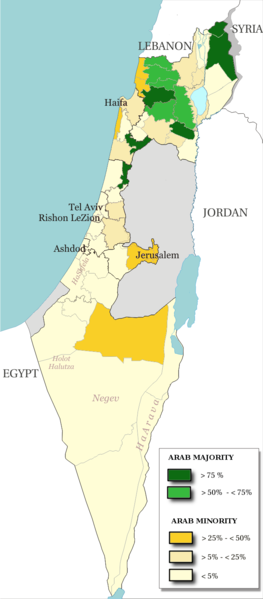
English: Map of the officials 50 "natural regions" of Israel, with their proportions of arab population. The map includ the Golan heights and east Jerusalem, two areas annexed by Israel, annexions not recognize by UNO. The map is based on the demographic situation 2000, and is based upon the arab population in Israel [PDF], a publication (Statistilite N°27) of the israeli Center Bureau of Statistics (CBS) diffused in november 2002.
Français : Carte des 50 "régions naturelles" officiellement reconnues par l'état, subdivision des 15 sous-districts, avec la proportion de population arabe. Cette carte inclue Jérusalem-Est et le plateau du Golan, tous deux annexés par Israël, mais dont l'annexion n'est pas reconnue par l'ONU. La carte est basée sur la situation de la population en l'an 2000, et est inspirée de the arab population in Israel [PDF], une publication (Statistilite N°27) du Center Bureau of Statistics israélien (CBS) diffusée en novembre 2002.
თარიღი
წყუ Own work, derivative work of: File:Israel population density.png
ავტორი Christophe cagé
სხვა ვერსიები File:Arabe population israel 2000 fr.png

ლიცენზირაფა

© ათე ნახანდაშ მინჯე, Israel Central Bureau of Statistics, ალობას არზენს არძას გჷმირინუას თინა ირნერი ღანკით თი პიჯალათ, დო მინჯე მოშინაფილ ქიჸუაფუ-და. ნახანდიშ გობჟინაფა, გინოჩამა დო კომერციული გჷმორინაფა ვაშილებე.
ავტორიშ მეწურაფა:
The Central Bureau of Statistics (CBS), {{{filename}}}, ({{{access-date}}}), [{{{link}}} available online] copied and distributed as is in accordance with the CBS license.

{{{template}}} According to the CBS license, you may not make the following use of the Information, whether by positive act or by omission:
  • present the Information in a misleading manner;
  • present the Information in a way that suggests that the Central Bureau of Statistics, or the State of Israel, supports or endorses you or your use of the Information;
  • make use of the Information in a manner that breaches any applicable law;
  • make use of the Information in a manner that infringes a person's privacy, including merging the Information with other sources of information with the intent of attempting to identify any individual person, business or organization;
  • present the Information in such a manner that gives the appearance that you may have received, or had access to, information held by the Office about any identifiable individual person, business or organization.
მე, ამ ნაწარმოებზე საავტორო უფლებების მფლობელი, საკუთარი სურვილით ვაქვეყნებ მას შემდეგი ლიცენზიით:
GNU head თქვა შეგილებჷნა გოფაჩათ ვარ-და დოთირუათ დოკუმენტი GNU Free Documentation ლიცენზიაშ 1.2 ვარ-და უმოსი უწმოხიანი ვერსიაშ პიჯალეფიშ მეჯინათ, ნამუთ გჷმობჟინაფილი რე დუდიშული პროგრამული აზარაშ ფონდიშენი, უთირუ გჷნართეფიშ უმუშო, მაართა დო ბოლო ხასჷლეფს მადვალუ ტექსტეფს. ლიცენზიაშ ანგი მილარე გჷნართას ჯოხოთ GNU Free Documentation License.
w:en:Creative Commons
ავტორიშ მეწურაფა კჷნ მანგი პიჯალეფით გობჟინაფა
ეს ნამუშევარი ვრცელდება Creative Commons Attribution-Share Alike 3.0 Unported, 2.5 Generic, 2.0 Generic და 1.0 Generic ლიცენზიით.
თქვა დუდიშულო შეილებჷნა:
  • ნახანდიშ გობჟინაფა – ნახანდიშ კოპირაფა, გობჟინაფა დო გჷნოჩამა.
  • დორსხილეფიშ აკოქიმინუა – ნახანდიშ გიშათინუა
გეჸვენჯი პიჯალეფით:
  • ავტორიშ მეწურაფა – თქვა წყუშ აკმაქიმინალი მეუწურუათ ოკო თი შარათ, მუჭოთ დარინუ ავტორქ ვარდა საავტორო ნებეფიშ მაღვენჯიქ. მარა ვართ თეშ, ითამ წყუშ ავტორქ ალობა მერჩეს თქვა ვარდა ალობა მეჩჷ თქვანიშით აკოქიმინელჷ ნოწარმუს.
  • კჷნ მანგი პიჯალეფით გობჟინაფა – დო თქვა ქოთირანთ, ვარ-და გჷთმაჭყანთ ახალ ნახანდის თე ნახანდიშ გჷმორინაფათ-და, თქვა გიღჷნა ნება თინა გაბჟინუათ კჷნ თი ვარ-და ომანგე ლიცენზიათ, ნამუშჷთ იბჟინუაფჷ წყუ.
თქვა შეგილებჷნა გიშაგორათ ლიცენზია.

Captions

Add a one-line explanation of what this file represents

media type ინგლისური

image/png

checksum ინგლისური

5afc0b91dfe8d983a85af862f3a58ec981a8a743

data size ინგლისური

186,138 ბაიტი

ფაილიშ ისტორია

ქიგუნჭირით რიცხვის/ბორჯის თიშო, ნამჷ-და ქოძირათ ფაილი თი რედაქციათ, ნამუ რედაქციას თი რიცხვის/ბორჯის რდუნ.

რიცხუ/ბორჯიჭკუდიგონზჷმილაფეფიმახვარებუკომენტარი
მიმალი17:48, 15 კვირკვე 2014ჭკუდი 17:48, 15 კვირკვე 2014-შო რინელჷ ვერსიაშო692 × 1,575 (182 კბ)Hruska~commonswikiReverted to version as of 08:23, 22 February 2009
17:47, 15 კვირკვე 2014ჭკუდი 17:47, 15 კვირკვე 2014-შო რინელჷ ვერსიაშო692 × 1,575 (182 კბ)Hruska~commonswikiReverted to version as of 08:23, 22 February 2009 Revert Edit, The Golan and East Jerusalem de facto Israel, Syria giving Status qo
17:46, 15 კვირკვე 2014ჭკუდი 17:46, 15 კვირკვე 2014-შო რინელჷ ვერსიაშო692 × 1,575 (182 კბ)Hruska~commonswikiReverted to version as of 08:23, 22 February 2009
19:38, 21 პირელი 2009ჭკუდი 19:38, 21 პირელი 2009-შო რინელჷ ვერსიაშო692 × 1,575 (165 კბ)MeteorMaker~commonswiki{{Information |Description={{en|1=Map of the officials 50 "natural regions" of Israel, with their proportions of arab population. The map includ the Golan heights and east Jerusalem, two areas annexed by Israel, annexions not recognize by UNO. The map is
12:23, 22 ფურთუთა 2009ჭკუდი 12:23, 22 ფურთუთა 2009-შო რინელჷ ვერსიაშო692 × 1,575 (182 კბ)Christophe cagé{{Information |Description={{en|1=x}} {{fr|1=x}} |Source=travail personnel (own work) |Author=Christophe cagé |Date=22 february 2009 |Permission=SEE LICENSE |other_versions= }} <!--{{ImageUpload|full}}-->

გეჸვენჯი ხასჷლა გჷმირინუანს თე ფაილს:

ფაილიშ გლობალური გჷმორინაფა

თე ფაილი გჷმირინუაფუ გეჸვენჯი ვიკეფს:

მეტამუნაჩემეფი