ფაილი:Bcamazonica.jpg
უმოს მაღალ გიშაგორანჯალა ვა რე შელებუან.
Bcamazonica.jpg (800 × 578 პიქსელი, ფაილიშ ზჷმა: 260 კბ, MIME ტიპი: image/jpeg)

|
ეს რუკა უნდა იყოს გადახატული .svg ფორმატში. ყოველივე ეს გვაძლევს რამდენიმე მოგებას, რის შესახებაც შეგიძლიათ წაიკითხოთ Commons:Media for cleanup. თუ თქვენ უკვე გაქვთ .svg ვერსია, ძალიან გთხოვთ ატვირთოთ იგი. ატვირთვის შემდეგ გთხოვთ შეცვალოთ ეს თარგი შემდეგით - {{Vector version available|ფაილის სახელი.svg}}.
|


| ეჭარუა |
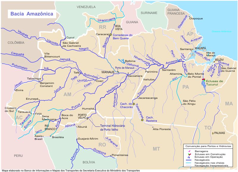
Português: O mapa mostra a região hidrográfica do Amazonas
English: Map showing the Amazonas watershed |
|||
| წყუ | https://web.archive.org/web/20090620080103/http://www.transportes.gov.br/bit/mapas/mapclick/hidro/bcamaz.htm | |||
| ავტორი | Secretaria Executiva do Ministério dos Transportes | |||
| ალობა: (ფაილიშ კინე გიმორინაფა) |
|
|||
| სხვა ვერსიები |
|


ფაილიშ ისტორია
ქიგუნჭირით რიცხვის/ბორჯის თიშო, ნამჷ-და ქოძირათ ფაილი თი რედაქციათ, ნამუ რედაქციას თი რიცხვის/ბორჯის რდუნ.
| რიცხუ/ბორჯი | ჭკუდი | გონზჷმილაფეფი | მახვარებუ | კომენტარი | |
|---|---|---|---|---|---|
| მიმალი | 22:19, 18 პირელი 2005 | | 800 × 578 (260 კბ) | Santana-freitas~commonswiki | Região Hidrográfica do Amazonas |
ფაილიშ გჷმორინაფა
გეჸვენჯი ხასჷლეფი გჷმირინუანა თე ფაილს:
ფაილიშ გლობალური გჷმორინაფა
თე ფაილი გჷმირინუაფუ გეჸვენჯი ვიკეფს:
- af.wikipedia.org-ს გჷმორინაფა
- ar.wikipedia.org-ს გჷმორინაფა
- arz.wikipedia.org-ს გჷმორინაფა
- azb.wikipedia.org-ს გჷმორინაფა
- be.wikipedia.org-ს გჷმორინაფა
- br.wikipedia.org-ს გჷმორინაფა
- ca.wikipedia.org-ს გჷმორინაფა
- ceb.wikipedia.org-ს გჷმორინაფა
- de.wikipedia.org-ს გჷმორინაფა
- en.wikipedia.org-ს გჷმორინაფა
- es.wikipedia.org-ს გჷმორინაფა
- Río Vaupés
- Río Tacutu
- Wikipedia:¿Sabías que.../enero de 2008
- Wikipedia:¿Sabías que.../4 de enero de 2008
- Usuario:Leandro10 3
- Usuario:Zero spartan
- Wikipedia:¿Sabías que.../1
- Wikipedia:¿Sabías que.../2
- Usuario:ElBeTa
- Wikipedia:¿Sabías que.../Todos
- Río Tefé
- Río Uatumã
- Río Coari
- Río Trombetas
- Río Nhamundá
ქოძირით, თე ფაილიშ გლობალური გიმორინაფა.