ფაილი:Cooch-behar-enclaves-schematisch.png
ზჷმა გიწოთოლორაფაშ ბორჯის: 307 × 599 პიქსელი. შხვა გოფართაფა: 123 × 240 პიქსელი | 246 × 480 პიქსელი | 393 × 768 პიქსელი | 1,100 × 2,148 პიქსელი.
ორიგინალი ფაილი (1,100 × 2,148 პიქსელი, ფაილიშ ზჷმა: 694 კბ, MIME ტიპი: image/png)

|
ეს რუკა უნდა იყოს გადახატული .svg ფორმატში. ყოველივე ეს გვაძლევს რამდენიმე მოგებას, რის შესახებაც შეგიძლიათ წაიკითხოთ Commons:Media for cleanup. თუ თქვენ უკვე გაქვთ .svg ვერსია, ძალიან გთხოვთ ატვირთოთ იგი. ატვირთვის შემდეგ გთხოვთ შეცვალოთ ეს თარგი შემდეგით - {{Vector version available|ფაილის სახელი.svg}}.
|
რეზიუმე
| ეჭარუა |
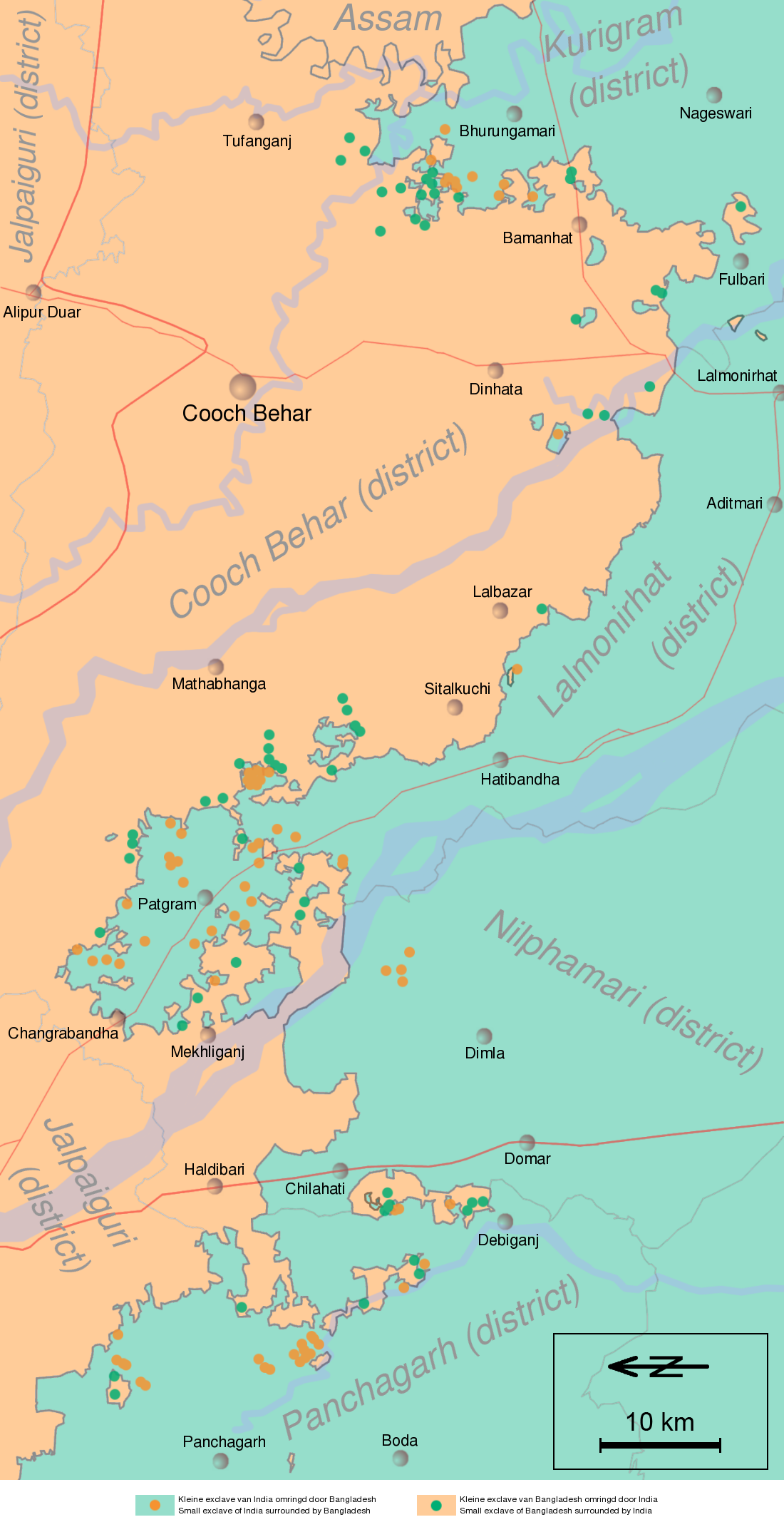
English: Schematic map of the Cooch Behar enclaves on the border of India and Bangladesh. The top of the map points to the east.
Nederlands: Schematische kaart van de Cooch Behar enclaves op de grens van India en Bangladesh. De bovenkant wijst naar het oosten. |
| თარიღი | (UTC) |
| წყუ | Information in "Waiting for the esquimo: An historical and documentary study of the Cooch Behar enclaves of India and Bangladesh" door Brendan R. Whyte (2002), [1], Google Maps and other map sources |
| ავტორი | Jeroen |
![[1]](http://geosite.jankrogh.com/enklaver/CoochBehar_Annotated.jpg)
ლიცენზირაფა
მე, ამ ნაწარმოებზე საავტორო უფლებების მფლობელი, საკუთარი სურვილით ვაქვეყნებ მას შემდეგი ლიცენზიით:

|
თქვა შეგილებჷნა გოფაჩათ ვარ-და დოთირუათ დოკუმენტი GNU Free Documentation ლიცენზიაშ 1.2 ვარ-და უმოსი უწმოხიანი ვერსიაშ პიჯალეფიშ მეჯინათ, ნამუთ გჷმობჟინაფილი რე დუდიშული პროგრამული აზარაშ ფონდიშენი, უთირუ გჷნართეფიშ უმუშო, მაართა დო ბოლო ხასჷლეფს მადვალუ ტექსტეფს. ლიცენზიაშ ანგი მილარე გჷნართას ჯოხოთ GNU Free Documentation License. |
| თე ნახანდი იბჟინუაფუ Creative Commons Attribution-Share Alike 3.0 Unported ლიცენზიათ. | ||
| ||
| ეს ლიცენზირების ნიშანი დაემატა ამ ფაილს, როგორც GFDL ლიცენზიის განახლების ნაწილი. |
ეს ნამუშევარი ვრცელდება Creative Commons Attribution-Share Alike 2.5 Generic, 2.0 Generic და 1.0 Generic ლიცენზიით.
- თქვა დუდიშულო შეილებჷნა:
- ნახანდიშ გობჟინაფა – ნახანდიშ კოპირაფა, გობჟინაფა დო გჷნოჩამა.
- დორსხილეფიშ აკოქიმინუა – ნახანდიშ გიშათინუა
- გეჸვენჯი პიჯალეფით:
- ავტორიშ მეწურაფა – თქვა წყუშ აკმაქიმინალი მეუწურუათ ოკო თი შარათ, მუჭოთ დარინუ ავტორქ ვარდა საავტორო ნებეფიშ მაღვენჯიქ. მარა ვართ თეშ, ითამ წყუშ ავტორქ ალობა მერჩეს თქვა ვარდა ალობა მეჩჷ თქვანიშით აკოქიმინელჷ ნოწარმუს.
- კჷნ მანგი პიჯალეფით გობჟინაფა – დო თქვა ქოთირანთ, ვარ-და გჷთმაჭყანთ ახალ ნახანდის თე ნახანდიშ გჷმორინაფათ-და, თქვა გიღჷნა ნება თინა გაბჟინუათ კჷნ თი ვარ-და ომანგე ლიცენზიათ, ნამუშჷთ იბჟინუაფჷ წყუ.
თქვა შეგილებჷნა გიშაგორათ ლიცენზია.
ატვირთვის ჟურნალი
| date/time | username | resolution | size | edit summary | |
|---|---|---|---|---|---|
| 12:03, 12 April 2008 | User:Gpvos | <a href="http://upload.wikimedia.org/wikipedia/commons/2/22/Cooch-behar-enclaves-systematisch.png[dead link]"><img alt="Thumbnail for version as of 12:03, 12 April 2008" src="http://upload.wikimedia.org/wikipedia/commons/thumb/2/22/Cooch-behar-enclaves-systematisch.png/61px-Cooch-behar-enclaves-systematisch.png[dead link]" width="61" height="119" border="0" /></a> | 1,100×2,148 | 642 KB | spelling fix (also optimized png) {{self|GFDL|cc-by-sa-2.5,2.0,1.0|author=<a href="/wiki/User:Jeroen" class="mw-redirect" title="User:Jeroen">User:Jeroen</a>}} |
| 22:53, 14 May 2007 | User:Jeroencommons | <a href="http://upload.wikimedia.org/wikipedia/commons/archive/2/22/20080412120354%21Cooch-behar-enclaves-systematisch.png[dead link]"><img alt="Thumbnail for version as of 22:53, 14 May 2007" src="http://upload.wikimedia.org/wikipedia/commons/thumb/archive/2/22/20080412120354%21Cooch-behar-enclaves-systematisch.png/61px-Cooch-behar-enclaves-systematisch.png[dead link]" width="61" height="119" border="0" /></a> | 1,100×2,148 | 690 KB | |
| 21:22, 13 May 2007 | User:Jeroencommons | <a href="http://upload.wikimedia.org/wikipedia/commons/archive/2/22/20070514225354%21Cooch-behar-enclaves-systematisch.png[dead link]"><img alt="Thumbnail for version as of 21:22, 13 May 2007" src="http://upload.wikimedia.org/wikipedia/commons/thumb/archive/2/22/20070514225354%21Cooch-behar-enclaves-systematisch.png/61px-Cooch-behar-enclaves-systematisch.png[dead link]" width="61" height="119" border="0" /></a> | 1,100×2,148 | 691 KB | {{Information |Description= Systematische kaart van de Cooch Behar enclaves op de grens van India en Bangladesh // Systematic map of the Cooch Behar enclaves on the border of India and Bangladesh |Source= Information in [http://eprints.unimelb.edu.au/arch |
ფაილიშ ისტორია
ქიგუნჭირით რიცხვის/ბორჯის თიშო, ნამჷ-და ქოძირათ ფაილი თი რედაქციათ, ნამუ რედაქციას თი რიცხვის/ბორჯის რდუნ.
| რიცხუ/ბორჯი | ჭკუდი | გონზჷმილაფეფი | მახვარებუ | კომენტარი | |
|---|---|---|---|---|---|
| მიმალი | 17:11, 29 გერგობათუთა 2011 | | 1,100 × 2,148 (694 კბ) | W like wiki | scale and north added |
| 08:38, 5 გჷმათუთა 2008 |  | 1,100 × 2,148 (642 კბ) | BetacommandBot | move approved by: User:Common Good This image was moved from Image:Cooch-behar-enclaves-systematisch.png == {{int:filedesc}} == {{Information |Description= Schematische kaart van de Cooch Behar enclaves op de grens van India en Bangladesh. De b |
ფაილიშ გჷმორინაფა
გეჸვენჯი ხასჷლა გჷმირინუანს თე ფაილს:
ფაილიშ გლობალური გჷმორინაფა
თე ფაილი გჷმირინუაფუ გეჸვენჯი ვიკეფს:
- bn.wikipedia.org-ს გჷმორინაფა
- ca.wikipedia.org-ს გჷმორინაფა
- de.wikipedia.org-ს გჷმორინაფა
- en.wikipedia.org-ს გჷმორინაფა
- es.wikipedia.org-ს გჷმორინაფა
- fi.wikipedia.org-ს გჷმორინაფა
- fr.wikipedia.org-ს გჷმორინაფა
- Liste d'enclaves et d'exclaves
- Enclaves indo-bangladaises
- Discussion:Enclaves indo-bangladaises
- Utilisateur:GhosterBot/BacASable/Le saviez-vous ?/Archives
- Wikipédia:Le saviez-vous ?/Archives/2023
- Wikipédia:Statistiques des anecdotes de la page d'accueil/Visibilité des anecdotes (2023)
- Wikipédia:Statistiques des anecdotes de la page d'accueil/Visibilité des anecdotes (2023)/2023 09
- Discussion:Enclaves indo-bangladaises/LSV 22579
- Wikipédia:Réseaux sociaux/X/Publications/archives/septembre 2023
- hi.wikipedia.org-ს გჷმორინაფა
- id.wikipedia.org-ს გჷმორინაფა
- it.wikipedia.org-ს გჷმორინაფა
- ja.wikipedia.org-ს გჷმორინაფა
- ko.wikipedia.org-ს გჷმორინაფა
- mt.wikipedia.org-ს გჷმორინაფა
- nl.wikipedia.org-ს გჷმორინაფა
- pl.wikipedia.org-ს გჷმორინაფა
- pt.wikipedia.org-ს გჷმორინაფა
- ru.wikipedia.org-ს გჷმორინაფა
- sq.wikipedia.org-ს გჷმორინაფა
- te.wikipedia.org-ს გჷმორინაფა
- th.wikipedia.org-ს გჷმორინაფა
- uk.wikipedia.org-ს გჷმორინაფა
- www.wikidata.org-ს გჷმორინაფა
- zh.wikipedia.org-ს გჷმორინაფა