ორიგინალი ფაილი(SVG ფაილი, ნომინალურო 2,020 × 3,140 პიქსელი, ფაილიშ ზჷმა: 289 კბ)

თე ფაილი რე Wikimedia Commons-შე დო შილებე გჷმორნაფილქ იჸუას შხვა პროექტეფს. თეშ ეჭარუა ფაილიშ ეჭარუაშ ხასჷლა თუდო რე მოჩამილი.

სურათი of the year
სურათი of the year
Featured სურათი

ვიკიოწკარუე

This file was a candidate in Picture of the Year 2007.
This is a featured picture on Wikimedia Commons (Featured pictures) and is considered one of the finest images.

If you have an image of similar quality that can be published under a suitable copyright license, be sure to upload it, tag it, and nominate it.

რეზიუმე

კამერის მდებარეობა36° 08′ 00″ ჩ. გ., 5° 21′ 00″ დ. გ. Kartographer map based on OpenStreetMap.იხილეთ ეს და სხვა ახლომდებარე სურათები საიტ(ებ)ზე OpenStreetMapinfo
ეჭარუა
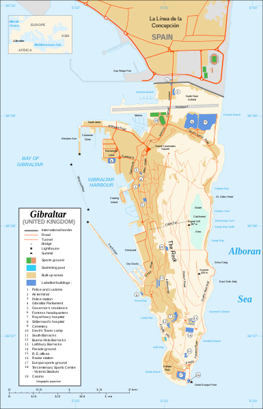
Čeština: Mapa ostrova Gibraltar v angličtině.
English: Map in English of Gibraltar.
Français : * Sujet : Carte en anglais de Gibraltar ;
  • Sources : Création personnelle ;
  • Carte créée à partir de captures d'écran d'images satellite de Google Earth d'un point de vue placé à 1,18 km d'altitude (imagerie disponible de novembre 2007) ;
  • Références complémentaires :
  • Échelle approximative : 1:40 000 (précision : environ 10 m) ;
  • Note : Largeur du tracé des routes proportionnelle à la réalité ;
  • Auteur : Eric Gaba (fr:Sting) ;
  • Date : Novembre 2007.
Português: Mapa (em Inglês) de Gibraltar.
თარიღი
წყუ Own work ;
Map created using screenshots of Google Earth satellite imagery from a point of view located at 1.18 km of altitude (available imagery of November 2007) ;
Other references :
* CIA map ;
* Gibnet map ;
* U.K. MoD map
Locator map : Image:Blank_map_of_South_Europe_and_North_Africa.svg (modified) created by Historicair ;
Approximate scale : 1:40,000 (accuracy : about 10 m)
Note : The roads width is proportional to reality
ავტორი Eric Gaba (Sting)
ალობა:
(ფაილიშ კინე გიმორინაფა)
Attribution and Share-Alike required
სხვა ვერსიები

[რედაქტირაფა]

Disputed isthmus and land
SVG genesis
InfoField
 
ამ SVG ფაილის კოდი კორექტულია.
 
This map was created with Inkscape…important.
 
 This map uses embedded text that can be easily translated using a text editor.

ლიცენზირაფა

მე, ამ ნაწარმოებზე საავტორო უფლებების მფლობელი, საკუთარი სურვილით ვაქვეყნებ მას შემდეგი ლიცენზიით:
GNU head თქვა შეგილებჷნა გოფაჩათ ვარ-და დოთირუათ დოკუმენტი GNU Free Documentation ლიცენზიაშ 1.2 ვარ-და უმოსი უწმოხიანი ვერსიაშ პიჯალეფიშ მეჯინათ, ნამუთ გჷმობჟინაფილი რე დუდიშული პროგრამული აზარაშ ფონდიშენი, უთირუ გჷნართეფიშ უმუშო, მაართა დო ბოლო ხასჷლეფს მადვალუ ტექსტეფს. ლიცენზიაშ ანგი მილარე გჷნართას ჯოხოთ GNU Free Documentation License.
w:en:Creative Commons
ავტორიშ მეწურაფა კჷნ მანგი პიჯალეფით გობჟინაფა
This file is licensed under the Creative Commons Attribution-Share Alike 4.0 International, 3.0 Unported, 2.5 Generic, 2.0 Generic and 1.0 Generic license.
თქვა დუდიშულო შეილებჷნა:
  • ნახანდიშ გობჟინაფა – ნახანდიშ კოპირაფა, გობჟინაფა დო გჷნოჩამა.
  • დორსხილეფიშ აკოქიმინუა – ნახანდიშ გიშათინუა
გეჸვენჯი პიჯალეფით:
  • ავტორიშ მეწურაფა – თქვა წყუშ აკმაქიმინალი მეუწურუათ ოკო თი შარათ, მუჭოთ დარინუ ავტორქ ვარდა საავტორო ნებეფიშ მაღვენჯიქ. მარა ვართ თეშ, ითამ წყუშ ავტორქ ალობა მერჩეს თქვა ვარდა ალობა მეჩჷ თქვანიშით აკოქიმინელჷ ნოწარმუს.
  • კჷნ მანგი პიჯალეფით გობჟინაფა – დო თქვა ქოთირანთ, ვარ-და გჷთმაჭყანთ ახალ ნახანდის თე ნახანდიშ გჷმორინაფათ-და, თქვა გიღჷნა ნება თინა გაბჟინუათ კჷნ თი ვარ-და ომანგე ლიცენზიათ, ნამუშჷთ იბჟინუაფჷ წყუ.
თქვა შეგილებჷნა გიშაგორათ ლიცენზია.

Captions

Add a one-line explanation of what this file represents

Commons quality assessment ინგლისური

Wikimedia Commons featured picture ინგლისური

coordinates of the point of view ინგლისური

36°7'59.999"N, 5°21'0.000"W

media type ინგლისური

image/svg+xml

ფაილიშ ისტორია

ქიგუნჭირით რიცხვის/ბორჯის თიშო, ნამჷ-და ქოძირათ ფაილი თი რედაქციათ, ნამუ რედაქციას თი რიცხვის/ბორჯის რდუნ.

რიცხუ/ბორჯიჭკუდიგონზჷმილაფეფიმახვარებუკომენტარი
მიმალი00:10, 22 ფურთუთა 2020ჭკუდი 00:10, 22 ფურთუთა 2020-შო რინელჷ ვერსიაშო2,020 × 3,140 (289 კბ)JoKalliauermalformed svg (compare firefox/chrome rendering with librsvg-rendering) actually firefox/chrome were correct, also it looks wrong
10:01, 29 მანგი 2017ჭკუდი 10:01, 29 მანგი 2017-შო რინელჷ ვერსიაშო2,020 × 3,140 (538 კბ)Wereldburger758Removal error in file. Valid SVG now.
01:52, 28 მარაშინათუთა 2008ჭკუდი 01:52, 28 მარაშინათუთა 2008-შო რინელჷ ვერსიაშო2,020 × 3,140 (569 კბ)RedCoatRemove "claimed by Spain", completely gratuitous for a map
15:28, 11 ქირსეთუთა 2007ჭკუდი 15:28, 11 ქირსეთუთა 2007-შო რინელჷ ვერსიაშო2,020 × 3,140 (570 კბ)StingNotification of the Spanish claims
18:40, 27 გერგობათუთა 2007ჭკუდი 18:40, 27 გერგობათუთა 2007-შო რინელჷ ვერსიაშო2,020 × 3,140 (569 კბ)StingAdditional names ; up-to-date corrections
01:35, 27 გერგობათუთა 2007ჭკუდი 01:35, 27 გერგობათუთა 2007-შო რინელჷ ვერსიაშო2,020 × 3,140 (561 კბ)RedCoatHouse of Assembly → Gibraltar Parliament
23:51, 26 გერგობათუთა 2007ჭკუდი 23:51, 26 გერგობათუთა 2007-შო რინელჷ ვერსიაშო2,020 × 3,140 (561 კბ)Sting+ info
18:12, 26 გერგობათუთა 2007ჭკუდი 18:12, 26 გერგობათუთა 2007-შო რინელჷ ვერსიაშო2,020 × 3,140 (561 კბ)Sting+ info
17:21, 26 გერგობათუთა 2007ჭკუდი 17:21, 26 გერგობათუთა 2007-შო რინელჷ ვერსიაშო2,020 × 3,140 (561 კბ)Sting{{Information |Description=Map in English of Gibraltar |Source=Own work ;<br/>Map created using screenshots of Google Earth satellite imagery from a point of view located at 1.18 km of altitude (available image

თე ფაილი აკა ხასჷლას ვეგჷმირინუაფუ.

ფაილიშ გლობალური გჷმორინაფა

თე ფაილი გჷმირინუაფუ გეჸვენჯი ვიკეფს:

მეტამუნაჩემეფი