ფაილი:Lake St Clair by Sentinel-2.jpg

ორიგინალი ფაილი (3,600 × 3,600 პიქსელი, ფაილიშ ზჷმა: 11.02 მბ, MIME ტიპი: image/jpeg)
რეზიუმე
| ეჭარუა |
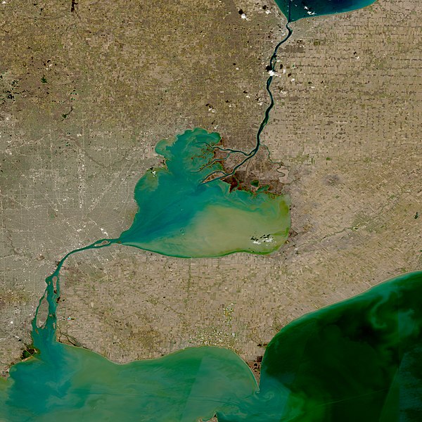
English: Lake St. Clair (Center), St Clair River (North; Connecting to Lake Huron), and Detroit River (South; Connecting to Lake Erie) taken by the Multi-Spectral instrument onboard the Sentinel-2 satellite on April 14, 2022. |
| თარიღი | Taken on 14 პირელი 2022 |
| წყუ | https://go.nasa.gov/3t3YkJS |
| ავტორი | Copernicus Programme |
ლიცენზირაფა

|
This image contains data from a satellite in the Copernicus Programme, such as Sentinel-1, Sentinel-2 or Sentinel-3. Attribution is required when using this image.
ავტორიშ მეწურაფა: Contains modified Copernicus Sentinel data 2022
The use of Copernicus Sentinel Data is regulated under EU law (Commission Delegated Regulation (EU) No 1159/2013 and Regulation (EU) No 377/2014). Relevant excerpts:
Free access shall be given to GMES dedicated data [...] made available through GMES dissemination platforms [...].
Access to GMES dedicated data [...] shall be given for the purpose of the following use in so far as it is lawful:
GMES dedicated data [...] may be used worldwide without limitations in time.
GMES dedicated data and GMES service information are provided to users without any express or implied warranty, including as regards quality and suitability for any purpose. |
| Annotations | This image is annotated: View the annotations at Commons |
ფაილიშ ისტორია
ქიგუნჭირით რიცხვის/ბორჯის თიშო, ნამჷ-და ქოძირათ ფაილი თი რედაქციათ, ნამუ რედაქციას თი რიცხვის/ბორჯის რდუნ.
| რიცხუ/ბორჯი | ჭკუდი | გონზჷმილაფეფი | მახვარებუ | კომენტარი | |
|---|---|---|---|---|---|
| მიმალი | 22:16, 12 მესი 2022 | | 3,600 × 3,600 (11.02 მბ) | TheWxResearcher | Uploaded a work by NASA, ESA from https://worldview.earthdata.nasa.gov/ with UploadWizard |
ფაილიშ გჷმორინაფა
გეჸვენჯი ხასჷლა გჷმირინუანს თე ფაილს:
ფაილიშ გლობალური გჷმორინაფა
თე ფაილი გჷმირინუაფუ გეჸვენჯი ვიკეფს:
- en.wikipedia.org-ს გჷმორინაფა
- th.wikipedia.org-ს გჷმორინაფა