ფაილი:Maksimovsky rock Chusovaya river.jpg

ზჷმა გიწოთოლორაფაშ ბორჯის: 703 × 599 პიქსელი. შხვა გოფართაფა: 282 × 240 პიქსელი | 563 × 480 პიქსელი | 928 × 791 პიქსელი.
ორიგინალი ფაილი (928 × 791 პიქსელი, ფაილიშ ზჷმა: 134 კბ, MIME ტიპი: image/jpeg)
| ეჭარუა |
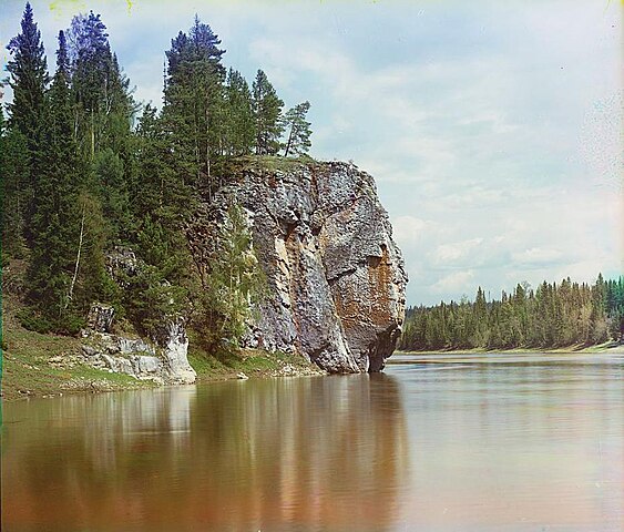
Русский: Максимовский камень около деревни Родина (река Чусовая). |
||||||||||||||||||||
| თარიღი | |||||||||||||||||||||
| წყუ |
Sergei Mikhailovich Prokudin-Gorskii Collection (Library of Congress)
|
||||||||||||||||||||
| ავტორი |
|
||||||||||||||||||||
| ალობა: (ფაილიშ კინე გიმორინაფა) |
There are no known restrictions on the use of this image. https://hdl.loc.gov/loc.pnp/res.237.prok | ||||||||||||||||||||


| კამერის მდებარეობა | | იხილეთ ეს და სხვა ახლომდებარე სურათები საიტ(ებ)ზე OpenStreetMap |
|---|
|
The author died in 1944, so this work is in the public domain in its country of origin and other countries and areas where the copyright term is the author's life plus 75 years or fewer. This work is in the public domain in the United States because it was published (or registered with the U.S. Copyright Office) before January 1, 1929. | |
| This file has been identified as being free of known restrictions under copyright law, including all related and neighboring rights. | |
ფაილიშ ისტორია
ქიგუნჭირით რიცხვის/ბორჯის თიშო, ნამჷ-და ქოძირათ ფაილი თი რედაქციათ, ნამუ რედაქციას თი რიცხვის/ბორჯის რდუნ.
| რიცხუ/ბორჯი | ჭკუდი | გონზჷმილაფეფი | მახვარებუ | კომენტარი | |
|---|---|---|---|---|---|
| მიმალი | 18:30, 12 კვირკვე 2005 | | 928 × 791 (134 კბ) | Hardscarf | Early color photograph from Russia, created by Sergei Mikhailovich Prokudin-Gorskii as part of his work to document the Russian Empire from 1909 to 1915. The Maksimovsky rock in the river Chusovaya in the [ |
ფაილიშ გჷმორინაფა
გეჸვენჯი ხასჷლა გჷმირინუანს თე ფაილს:
ფაილიშ გლობალური გჷმორინაფა
თე ფაილი გჷმირინუაფუ გეჸვენჯი ვიკეფს:
- af.wikipedia.org-ს გჷმორინაფა
- ang.wikipedia.org-ს გჷმორინაფა
- arz.wikipedia.org-ს გჷმორინაფა
- ast.wikipedia.org-ს გჷმორინაფა
- azb.wikipedia.org-ს გჷმორინაფა
- az.wikipedia.org-ს გჷმორინაფა
- ba.wikipedia.org-ს გჷმორინაფა
- be-tarask.wikipedia.org-ს გჷმორინაფა
- be.wikipedia.org-ს გჷმორინაფა
- bg.wikipedia.org-ს გჷმორინაფა
- bxr.wikipedia.org-ს გჷმორინაფა
- ca.wikipedia.org-ს გჷმორინაფა
- ceb.wikipedia.org-ს გჷმორინაფა
- cv.wikipedia.org-ს გჷმორინაფა
- da.wikipedia.org-ს გჷმორინაფა
- de.wikipedia.org-ს გჷმორინაფა
- en.wikipedia.org-ს გჷმორინაფა
- en.wikivoyage.org-ს გჷმორინაფა
- eo.wikipedia.org-ს გჷმორინაფა
- es.wikipedia.org-ს გჷმორინაფა
- et.wikipedia.org-ს გჷმორინაფა
- fi.wikipedia.org-ს გჷმორინაფა
- fr.wikipedia.org-ს გჷმორინაფა
- he.wikivoyage.org-ს გჷმორინაფა
- hi.wikipedia.org-ს გჷმორინაფა
- hr.wikipedia.org-ს გჷმორინაფა
- hu.wikipedia.org-ს გჷმორინაფა
- hy.wikipedia.org-ს გჷმორინაფა
- it.wikipedia.org-ს გჷმორინაფა
- ja.wikipedia.org-ს გჷმორინაფა
ქოძირით, თე ფაილიშ გლობალური გიმორინაფა.