ფაილი:Noord-Brabant position.svg

ათე SVG ფაილიშ PNG გიწოთოლორაფაშ ზჷმა რე: 200 × 236 პიქსელი. შხვა გოფართაფა: 203 × 240 პიქსელი | 407 × 480 პიქსელი | 651 × 768 პიქსელი | 868 × 1,024 პიქსელი | 1,736 × 2,048 პიქსელი.
ორიგინალი ფაილი (SVG ფაილი, ნომინალურო 200 × 236 პიქსელი, ფაილიშ ზჷმა: 158 კბ)
რეზიუმე
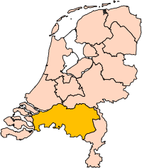
| ეჭარუა | Location of the province of Noord-Brabant (North Brabant) in the Netherlands. |
| თარიღი | |
| წყუ | Own work, based on freely available GIS data |
| ავტორი | User:Mtcv |
| ალობა: (ფაილიშ კინე გიმორინაფა) |
Data: attribution required; my work: PD |
| სხვა ვერსიები | I attempted to make an svg version of Image:Noord Brabant-Position.png (with less simplified boundaries) |
Clickable version

ლიცენზირაფა

|
ათე ნახანდაშ მინჯე, Centraal Bureau voor de Statistiek, ალობას არზენს არძას გჷმირინუას თინა ირნერი ღანკით თი პიჯალათ, დო მინჯე მოშინაფილ ქიჸუაფუ-და. ნახანდიშ გობჟინაფა, გინოჩამა დო კომერციული გჷმორინაფა ვაშილებე. |
ავტორიშ მეწურაფა:
|
| Annotations | This image is annotated: View the annotations at Commons |


ფაილიშ ისტორია
ქიგუნჭირით რიცხვის/ბორჯის თიშო, ნამჷ-და ქოძირათ ფაილი თი რედაქციათ, ნამუ რედაქციას თი რიცხვის/ბორჯის რდუნ.
| რიცხუ/ბორჯი | ჭკუდი | გონზჷმილაფეფი | მახვარებუ | კომენტარი | |
|---|---|---|---|---|---|
| მიმალი | 21:20, 2 მელახი 2019 | | 200 × 236 (158 კბ) | Thayts | update |
| 04:49, 3 გჷმათუთა 2006 |  | 200 × 236 (158 კბ) | Mtcv | {{Information| |Description=Location of the province of Noord-Holland (North Holland) in the Netherlands. |Source=Own work, based on freely available GIS data |Date=2006-10-03 |Author=User:Mtcv |Permission=Data: attribution required; my work: PD |othe |
ფაილიშ გჷმორინაფა
თე ფაილი აკა ხასჷლას ვეგჷმირინუაფუ.
ფაილიშ გლობალური გჷმორინაფა
თე ფაილი გჷმირინუაფუ გეჸვენჯი ვიკეფს:
- ar.wikipedia.org-ს გჷმორინაფა
- شمال بربنت
- آيندهوفن
- بريدا
- بارله ناساو
- تيلبورخ
- سيرتوخيمبوس
- قالب:بلديات شمال برابنت
- آلبورخ
- ألفن- كام
- أستن
- بيرخ آيك
- فيلدهوفن
- بيرخن أوب زووم
- بيرنهيزه
- بيست (هولندا)
- بلادل
- بوكل
- بوكسمير
- بوكستل
- كرانندونك
- كاوك
- دورنه
- دونجن
- دريميلين
- إيرسل
- إيتن- لور
- خيرتراودنبيرخ
- خيلدروب- ميرلو
- خيميرت- باكل
- خيلزه آن راين
- خورلا
- خرافه (هولندا)
- هارن (شمال برابنت)
- هالدربيرخه
- هيزه- لينده
- هيلموند
- هوسدن
- هيلفارينبيك
- لاربيك
- لانديرد
- لوب أوب زند
- مل آن سينت هوبرت
- موردايك
- نونن (خيرفن آن نيدرفيتن)
- أويرشخوت
- أويسترفايك
- أوسترهاوت
- أوس (هولندا)
- روسل- دي ميردن
- روسيندال
ქოძირით, თე ფაილიშ გლობალური გიმორინაფა.