ორიგინალი ფაილი(631 × 648 პიქსელი, ფაილიშ ზჷმა: 63 კბ, MIME ტიპი: image/png)

თე ფაილი რე Wikimedia Commons-შე დო შილებე გჷმორნაფილქ იჸუას შხვა პროექტეფს. თეშ ეჭარუა ფაილიშ ეჭარუაშ ხასჷლა თუდო რე მოჩამილი.

რეზიუმე

ეჭარუა
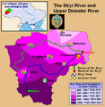
English: This is a map showing the Upper Dniestr River Basin, including its main tributary, the Stryi River, in the southwestern half of the Lviv Oblast in western Ukraine. It also shows the average annual precipitation by millimeters and inches for the region, and places the administrative centers of each of the raions in this area on the map. It includes and inset indicating where this is in relation to the rest of Ukraine, and provides the names of the closest villages to the Stryi River's head and mouth. I created this map, using Microsoft Paint, version 7.0, and borrowing data from Google Earth, and the 21st European Regional Conference 2005 - 15-19 May 2005 - Frankfurt (Oder) and Slubice - Germany and Poland report on "Floods Modeling in the Upper Dnister River Valley", by Ivan Kovalchuk, Andriy Mykhnovych, Volker Ehlert, Jörg Steidl, in conjunction with the Leibniz Centre for Agricultural Landscape Research (ZALF), Germany, and held at the Ivan Franko National University of L’viv, Ukraine, page4. URL: http://www.zalf.de/icid/ICID_ERC2005/HTML/ERC2005PDF/Topic_2/Kovalchuk.pdf
თარიღი 10 ფურთუთა 2010 (original upload date)
წყუ Transferred from en.wikipedia to Commons by SreeBot.
ავტორი Saukkomies at ინგლისური ვიკიპედია

ლიცენზირაფა

Public domain ეს ნამუშევარი მისი ავტორის Saukkomies at ინგლისური ვიკიპედია მიერ გადაცემულია საზოგადოებრივ დომენში. ეს მოქმედებს მთელი მსოფლიოს მასშტაბით.
ზოგიერთ ქვეყანაში ეს შეიძლება იურიდიულად შეუძლებელი იყოს, ასეთ შემთხვევაში:
Saukkomies უფლება მისცა ნებისმიერს, რათა გამოიყენონ ეს ნამუშევარი ნებისმიერი მიზნით, ყოველგვარი წინაპირობის გარეშე, თუ რაიმე პირობა კანონის მიერ არ არის მოთხოვნილი.

ატვირთვის ჟურნალი

The original description page was here. All following user names refer to en.wikipedia.

Upload date | User | Bytes | Dimensions | Comment

  • 2010-02-10 01:12 (UTC) | Saukkomies | 64995 (bytes) | 631×648 | I created this map, using Microsoft Paint, version 7.0, and borrowing data from Google Earth, and the 21st European Regional Conference 2005 - 15-19 May 2005 - Frankfurt (Oder) and Slubice - Germany and Poland report on "Floods Modeling in the Upper Dnist

Captions

Add a one-line explanation of what this file represents

ფაილიშ ისტორია

ქიგუნჭირით რიცხვის/ბორჯის თიშო, ნამჷ-და ქოძირათ ფაილი თი რედაქციათ, ნამუ რედაქციას თი რიცხვის/ბორჯის რდუნ.

რიცხუ/ბორჯიჭკუდიგონზჷმილაფეფიმახვარებუკომენტარი
მიმალი21:36, 18 ეკენია 2011ჭკუდი 21:36, 18 ეკენია 2011-შო რინელჷ ვერსიაშო631 × 648 (63 კბ)SreeBot(Original text) : I created this map, using Microsoft Paint, version 7.0, and borrowing data from Google Earth, and the 21st European Regional Conference 2005 - 15-19 May 2005 - Frankfurt (Oder) and Slubice - Germany and Poland report on "Floods Modeling

გეჸვენჯი ხასჷლა გჷმირინუანს თე ფაილს:

ფაილიშ გლობალური გჷმორინაფა

თე ფაილი გჷმირინუაფუ გეჸვენჯი ვიკეფს: