ფაილი:Troas.png
უმოს მაღალ გიშაგორანჯალა ვა რე შელებუან.
Troas.png (520 × 539 პიქსელი, ფაილიშ ზჷმა: 113 კბ, MIME ტიპი: image/png)
რეზიუმე
| ეჭარუა |
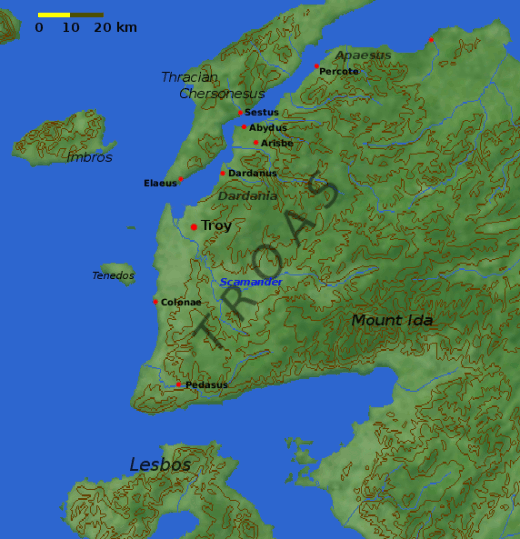
Deutsch: Landkarte der Troas
English: Map of the Troad, including the site of Troy. Note that the modern coastline has been altered to show a bay at the mouth of Scamander where the Greek ships would have been.
Nederlands: ligging en omgeving van Troje |
| თარიღი | 4 ქირსეთუთა 2004 (original upload date) |
| წყუ | Transferred from en.wikipedia to Commons. |
| ავტორი |
Dbachmann at ინგლისური ვიკიპედია Later versions were uploaded by Joy at en.wikipedia. |
| სხვა ვერსიები |
Derivative works of this file: Ancient edremit gulf.jpg
|


|
Please translate the English parts of this template into Georgian.
არსებობს ამ გამოსახულების ვექტორული ანალოგი ("SVG"). It should be used in place of this raster image. File:Troas.png → File:Troas.svg
ვექტორულ გრაფიკაზე ინფორმაციის მისაღებად, გთხოვთ იხილოთ ფაილების SVG ფორმატში გადაყვანის ინსტრუქცია. ასევე არსებობს ტექნიკური ინფორმაცია ფორმატ SVG-ის მხარდაჭერის შესახებ MediaWiki-ში. |
 |
ლიცენზირაფა

|
თქვა შეგილებჷნა გოფაჩათ ვარ-და დოთირუათ დოკუმენტი GNU Free Documentation ლიცენზიაშ 1.2 ვარ-და უმოსი უწმოხიანი ვერსიაშ პიჯალეფიშ მეჯინათ, ნამუთ გჷმობჟინაფილი რე დუდიშული პროგრამული აზარაშ ფონდიშენი, უთირუ გჷნართეფიშ უმუშო, მაართა დო ბოლო ხასჷლეფს მადვალუ ტექსტეფს. ლიცენზიაშ ანგი მილარე გჷნართას ჯოხოთ GNU Free Documentation License. |
| თე ნახანდი იბჟინუაფუ Creative Commons Attribution-Share Alike 3.0 Unported ლიცენზიათ. | ||
| ||
| ეს ლიცენზირების ნიშანი დაემატა ამ ფაილს, როგორც GFDL ლიცენზიის განახლების ნაწილი. |
|
NOTE: "subject to disclaimers" below may not actually apply, this was tagged with {{GFDL-user-en}}, and after May 2007, en:Template:GFDL-self did not require disclaimers. Please check the image description page on the English Wikipedia (or, if it has been deleted, ask an English Wikipedia administrator). See Wikipedia:GFDL standardization for details. | ||
Joy from en.wikipedia.org, ამ ნამუშევარზე საავტორო უფლებების მფლობელი, ვაქვეყნებ მას შემდეგი ლიცენზიით:
| ||
|
Note: This tag should not be used. For images that were released on the English Wikipedia using either GFDL or GFDL-self with disclaimers, use {{GFDL-user-en-with-disclaimers}}. For images without disclaimers please use {{GFDL-user-en-no-disclaimers}} instead. If you are the copyright holder of files that were released on Wikipedia, please consider removing the disclaimers. |
ატვირთვის ჟურნალი
- 2005-03-06 14:15 Joy 520×539×8 (115389 bytes) reduced palette to 256 colors to halve the file size with negligible visual impact (reducing to 150 colors drops some 15KB more but it's not worth it)
- 2004-12-15 13:50 Dbachmann 520×539×8 (286334 bytes) scale
- 2004-12-04 15:03 Dbachmann 447×475×8 (193411 bytes) update position of Troy
- 2004-12-04 13:34 Dbachmann 450×489×8 (203976 bytes) '
- 2004-12-04 12:43 Dbachmann 470×519×8 (228694 bytes) {{GFDL}}
ფაილიშ ისტორია
ქიგუნჭირით რიცხვის/ბორჯის თიშო, ნამჷ-და ქოძირათ ფაილი თი რედაქციათ, ნამუ რედაქციას თი რიცხვის/ბორჯის რდუნ.
| რიცხუ/ბორჯი | ჭკუდი | გონზჷმილაფეფი | მახვარებუ | კომენტარი | |
|---|---|---|---|---|---|
| მიმალი | 09:37, 11 ღურთუთა 2006 | | 520 × 539 (113 კბ) | Olliminatore | from en: |
ფაილიშ გჷმორინაფა
გეჸვენჯი ხასჷლა გჷმირინუანს თე ფაილს:
ფაილიშ გლობალური გჷმორინაფა
თე ფაილი გჷმირინუაფუ გეჸვენჯი ვიკეფს:
- af.wikipedia.org-ს გჷმორინაფა
- am.wikipedia.org-ს გჷმორინაფა
- ar.wikipedia.org-ს გჷმორინაფა
- arz.wikipedia.org-ს გჷმორინაფა
- azb.wikipedia.org-ს გჷმორინაფა
- az.wikipedia.org-ს გჷმორინაფა
- ba.wikipedia.org-ს გჷმორინაფა
- be.wikipedia.org-ს გჷმორინაფა
- bg.wikipedia.org-ს გჷმორინაფა
- bn.wikipedia.org-ს გჷმორინაფა
- br.wikipedia.org-ს გჷმორინაფა
- ceb.wikipedia.org-ს გჷმორინაფა
- ce.wikipedia.org-ს გჷმორინაფა
- cs.wikipedia.org-ს გჷმორინაფა
- cy.wikipedia.org-ს გჷმორინაფა
- el.wikipedia.org-ს გჷმორინაფა
- en.wikipedia.org-ს გჷმორინაფა
- es.wikipedia.org-ს გჷმორინაფა
- eu.wikipedia.org-ს გჷმორინაფა
- fi.wikipedia.org-ს გჷმორინაფა
- fr.wikipedia.org-ს გჷმორინაფა
- fy.wikipedia.org-ს გჷმორინაფა
- he.wikipedia.org-ს გჷმორინაფა
- hr.wikipedia.org-ს გჷმორინაფა
- hu.wikipedia.org-ს გჷმორინაფა
- id.wikipedia.org-ს გჷმორინაფა
ქოძირით, თე ფაილიშ გლობალური გიმორინაფა.