ფაილი:Un-nepal.png

ორიგინალი ფაილი (3,038 × 2,257 პიქსელი, ფაილიშ ზჷმა: 1.56 მბ, MIME ტიპი: image/png)
რეზიუმე
| ეჭარუა |
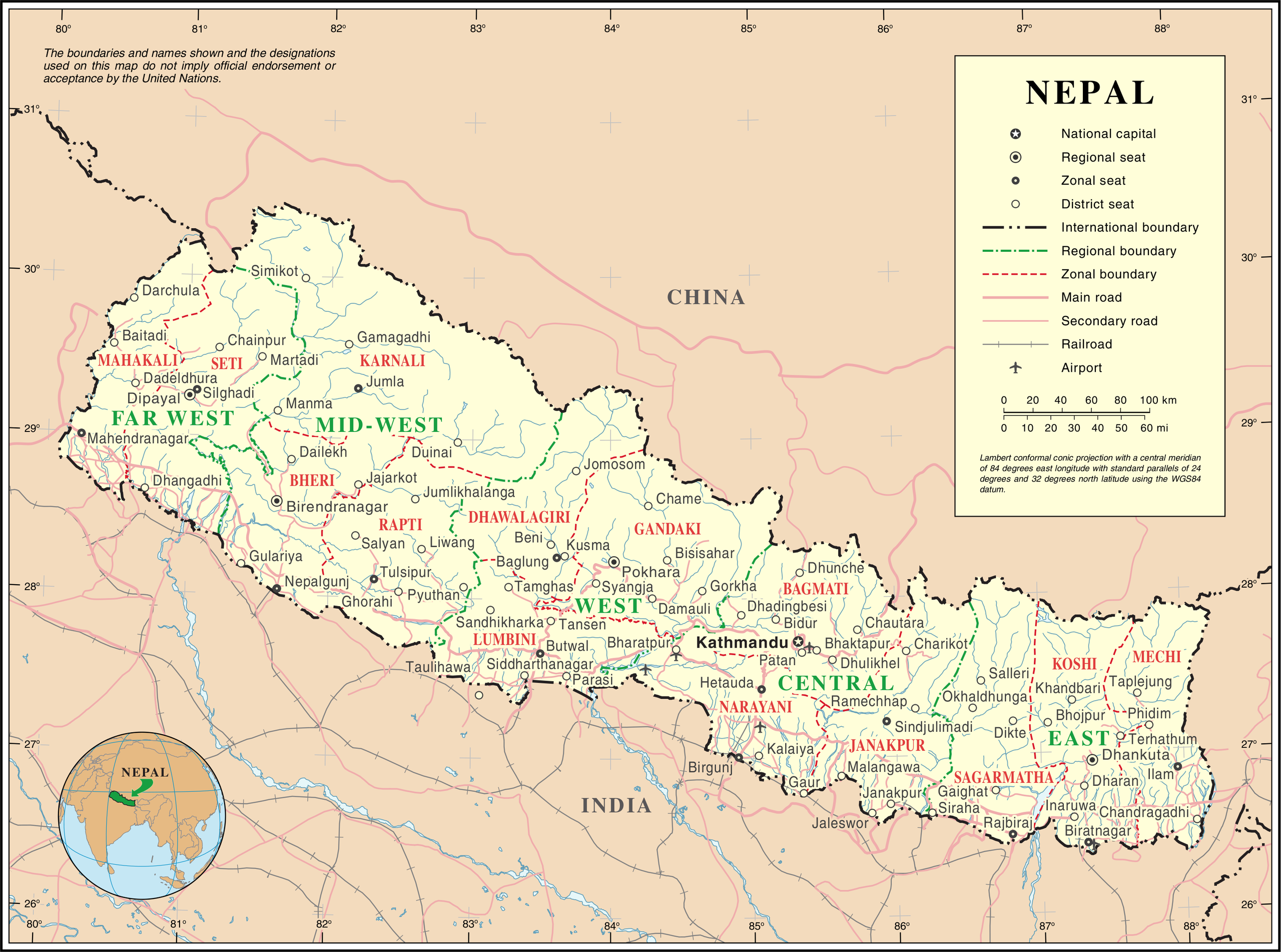
English: Map of Nepal highlighting development regions (green) and administrative zones (red), both disestablished in 2015 |
|||
| თარიღი | before 25 გჷმათუთა 2007 | |||
| წყუ | United Nations | |||
| ავტორი | უცნობი | |||
| ალობა: (ფაილიშ კინე გიმორინაფა) |
|

ფაილიშ ისტორია
ქიგუნჭირით რიცხვის/ბორჯის თიშო, ნამჷ-და ქოძირათ ფაილი თი რედაქციათ, ნამუ რედაქციას თი რიცხვის/ბორჯის რდუნ.
| რიცხუ/ბორჯი | ჭკუდი | გონზჷმილაფეფი | მახვარებუ | კომენტარი | |
|---|---|---|---|---|---|
| მიმალი | 05:36, 24 გჷმათუთა 2007 | | 3,038 × 2,257 (1.56 მბ) | Jeroen | {{UN map}} Category:Maps of Nepal |
ფაილიშ გჷმორინაფა
გეჸვენჯი ხასჷლა გჷმირინუანს თე ფაილს:
ფაილიშ გლობალური გჷმორინაფა
თე ფაილი გჷმირინუაფუ გეჸვენჯი ვიკეფს:
- af.wikipedia.org-ს გჷმორინაფა
- az.wikipedia.org-ს გჷმორინაფა
- ba.wikipedia.org-ს გჷმორინაფა
- bh.wikipedia.org-ს გჷმორინაფა
- ca.wikipedia.org-ს გჷმორინაფა
- de.wikipedia.org-ს გჷმორინაფა
- en.wikipedia.org-ს გჷმორინაფა
- fi.wikipedia.org-ს გჷმორინაფა
- fr.wikipedia.org-ს გჷმორინაფა
- hyw.wikipedia.org-ს გჷმორინაფა
- ja.wikipedia.org-ს გჷმორინაფა
- krc.wikipedia.org-ს გჷმორინაფა
- nl.wikipedia.org-ს გჷმორინაფა
- pap.wikipedia.org-ს გჷმორინაფა
- pcd.wikipedia.org-ს გჷმორინაფა
- pl.wiktionary.org-ს გჷმორინაფა
- roa-rup.wikipedia.org-ს გჷმორინაფა
- ru.wikipedia.org-ს გჷმორინაფა
- sco.wikipedia.org-ს გჷმორინაფა
- sl.wikipedia.org-ს გჷმორინაფა
- ta.wikipedia.org-ს გჷმორინაფა
- th.wikipedia.org-ს გჷმორინაფა
- tr.wikipedia.org-ს გჷმორინაფა
- uk.wikipedia.org-ს გჷმორინაფა
- ur.wikipedia.org-ს გჷმორინაფა
- www.wikidata.org-ს გჷმორინაფა